
How to draw on a map?
Use the Draw tool to draw on the map. The standard drawing type is Points. Drawing is only available in E-Maps Advanced and E-Maps Mobility Pro.
To get more drawing types, click on the arrow.
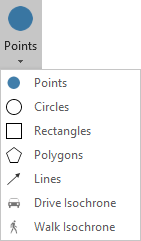
Points: Draws a point on the map.
Circles: Draws a circle on the map. You can select the number of circles and the radius.
Rectangles: Draws a rectangle on the map.
Polygons: Draws a polygon on the map. Double click to stop drawing the polygon.
Lines: Draws a line on the map. Double click to stop drawing the line.
E-Maps Mobility Pro version only
Drive Isochrone: Draws an area on the map that is reachable by car, you can select the range or the amount of time.
Walk Isochrone: Draws an area on the map that is reachable by foot, you can select the range or the amount of time.
Drawing on the map will create a DrawingLayer, you can customize the color of the layer in the Layers menu. To create multiple drawing layers, rename the current DrawingLayer and create a new drawing, this will also create a new DrawingLayer. For more information about layers, see the Layer control tutorial.