
Excel E-Maps update history and download
Note: read our License Agreement before downloading E-Maps and using the software application.
Some release notes will be removed or made more compact after new releases.
How to get the latest E-Maps release. Suitable for new users and as upgrade for current users:
- Download the installer: E-Maps.exe (76 MB)
- Having problems using the self extracting executable?
Download E-Maps_Installers.zip (115 MB), extract the files to your computer and run E-Maps setup.exe.
Release notes
E-Maps 2.2.8 (April 2026)
- Improved Travel Order performance
E-Maps 2.2.7 (December 2024)
- Updated HERE Maps to the latest version.
- You can now choose any background map for HERE Traffic.
E-Maps 2.2.6 (May 2024)
- Improved the geocoding performance of large data sets.
E-Maps 2.2.5 (Januari 2024)
- Updated the PDOK maps to use the new PDOK webservices.
E-Maps 2.2.4 (Oktober 2023)
- Updated the areal PDOK map to a higher resolution.
E-Maps 2.2.3 (Oktober 2023)
- Fixed some PDOK features.
E-Maps 2.2.2 (August 2022)
- Improved geocoder.
E-Maps 2.2.1 (December 2021)
- Small improvements in the installer.
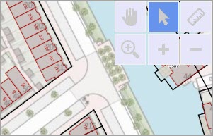
E-Maps 2.2 (November 2021)
The map window now has a select tool button for faster switching between panning and selecting.
- Performance improvement for thematic maps.
- The last selected background map will be set as default for the next time you start E-Maps.
E-Maps 2.1.0.3 (February 2021)
- Significant performance improvements for loading and geocoding large datasets.
- Export to SHP from the Drawing Layer (E-Maps Advanced).
- Better positioning data which is added to the map in combination with a shapefile.
- A long awaited feature, the distance measure tool (ruler)
- New functionality in E-Maps Advanced: point in polygon select points within an imported Shape (.shp) boundary or your own created polygons.
E-Maps 2.0.6.5 (January 2020)
- New version (v4) of cadastral map in PDOK version.
- Improved zoom levels for AHN3 maps in PDOK version.
- Drawn objects and isochrones can be saved in the project file (Advanced and Mobility version only).
- Project files now also support the label function.
E-Maps 2.0.3.4 (January 2018)
- Three new map types for contemporary maps: Hybrid (no labels), Reduced and Reduced (no roads)
- New map layers for PDOK version (for The Netherlands only).
- Improved geocoding for PDOK version (for The Netherlands only).
- Statistics window for numeric content of selected records (Advanced and Mobility versions).
- Expand your selection in the same layer by holding the Ctrl-key while selecting.
E-Maps 2.0.1.0 (February 2017)
- We added circle selections to the E-Maps Pro version.
- Added OSM Transportation layer for mobility version.
- Mobility versions now support multiple modality route calculations simultaneously.
- Enhanced search when having the full address in one column.
- Automatic check for updates changed to once every 3 days instead of every time.
- Added functionality to modify heatmap colors and values for the Advanced version
- Project files now contain relative paths, which makes it possible to copy or move the files together
E-Maps 2.0.0.70 (March 2016)
- Release of the new E-Maps Advanced version
- Performance improvement for loading a SHP (ESRI shape) file
- Release of E-Maps Mobility Pro
- Added option for modifying map size and map zoom
E-Maps 2.0.0.15 (July 2015)
- New release (version 2.0)
- Enhanced usability
- Redesigned buttons