
Put your data on a map in Excel™, just in a few clicks!
Excel E-Maps is the most user friendly GIS viewer for all Excel desktop.
Specifications
- plot your addresses on a map. Geocode based on postcode, full address or partial address.
- create a map based on X and Y coordinates (WGS84)
- find an address and display the location on the map integrated in Excel
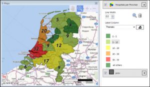
- create thematic maps: thematic points, pie charts, bar charts and heatmaps
- do spatial analysis with E-MapsAdvanced
- export maps as an image, layered PDF or just print
- works with Excel 2007, 2010, 2013, 2016, 2019 and Office 365 desktop.
E-Maps for Excel™ is available in three versions
- Standard – worldwide geocoding based on full address, postal code or city. Background maps ranging from From High quality maps from Here ™ to a blank map.
- Pro – all features of the Standard version plus extra background maps and enhanced selection capabilities like circle and marquee. Import your own Esri Shape file as background layer or colour it as a thematic map.
- Advanced – all features of the Pro version plus advanced selecting and drawing capabilities. Make a selection of locations based on travel time and/or -distance from a given point using car or walking. Draw a line, circles, shapes or a point to enhance your maps
For more information take a look at the comparison table.