
What is MapPoint? 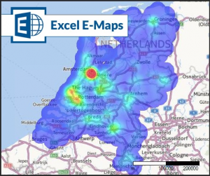
Since 2000 organizations used Microsoft MapPoint for quick geographic insights. The tool had background maps for large parts of the world. Within the most countires, you were able to geocode addresses. The software and the maps had to be installed on a (network) harddrive.
People used MapPoint for quick geographic visualisations and analyses of their own Microsoft Acces or MS Excel data. In selected countries isoline routing was available as well. By the end of 2014, Microsoft stopped developing MapPoint.
Excel E-Maps the successor of MapPoint
What comes after MapPoint is the Excel mapping plug-in E-Maps. The easy to use add-in E-Maps provides worldwide advanced geocoding, based on address, postal code or city names. The Excel add-in is the best tool for GEO analysis with features like heatmap, choroplets and other thematic mapping. E-Maps uses the up-to-date map and geocoding engine from Here ™.
Isochrones and routing capabilities are available in E-Maps Mobility.
Download a free 14-day trial or order E-Maps in the First Element webshop.
![]()
![]()